
Follow the trail, step by step.
With the Komoot app, you can check the interactive map, GPS track, and all the technical information to tackle each itinerary at your best. Below you will find a selection of the main hiking routes to Rifugio Vallanta and its surroundings, which you can also view on the app.
Discover the appSuggested Routes
We propose some of the most common routes of the “Giro del Viso”, offering different options based on the time available and the difficulty of the trail. Our list also includes a family-friendly Giro del Viso, as well as an alpine version suitable only for those with solid hiking/mountaineering skills. Due to its long distance (about 50 km), the “Giro del Viso” should only be undertaken with good training and the ability to move confidently across varied terrain (rocky slopes, snowfields, exposed trails, etc.).
Day 1: Pian del Re – Rifugio Vallanta. Departure from Pian del Re (2020 m) in Valle Po, Colle delle Traversette (2950 m) or alternatively Buco di Viso (2882 m), descent to the French refuge Mont Viso (2460 m), ascent to Colle di Vallanta (2811 m), Rifugio Vallanta (2450 m) and overnight stay.
Day 2: Rifugio Vallanta (Valle Varaita) – Pian del Re. Departure from Rifugio Vallanta (2450 m), Passo S. Chiaffredo (2764 m) in the Vallone delle Giargiatte, Passo Gallarino (2727 m), Rifugio Quintino Sella (2640 m), Pian del Re (2020 m).
Day 1: Pian del Re (2020 m) – Rifugio Quintino Sella (2640 m) or Rifugio Alpetto (2268 m) Estimated time: 3 hours.
Day 2: Rifugio Sella or Alpetto – Rifugio Vallanta. Passo Gallarino (2727 m), Passo S. Chiaffredo (2764 m), Vallone delle Giargiatte up to Grange Gheit (1912 m), ascent of Vallone di Vallanta up to the refuge of the same name and overnight stay. Estimated time: 5–6 hours.
Day 3: Rifugio Vallanta (2450 m) – Pian del Re (2020 m) Colle di Vallanta (2811 m), descent to the French refuge Mont Viso (2460 m), Colle delle Traversette (2950 m) or alternatively Buco di Viso (2882 m), Pian del Re (2020 m). Estimated time: 6 hours.
Day 1: Castello di Pontechianale (1603 m) in Valle Varaita – Rifugio Giacoletti (2741 m). Departure from Castello (1603 m), Vallone di Vallanta up to Grange Gheit (1912 m), junction for Passo S. Chiaffredo (2764 m), Vallone delle Giargiatte, Passo Gallarino (2727 m), Rifugio Quintino Sella (2640 m), Rifugio Giacoletti (2741 m) and overnight stay. Estimated time: 7 hours.
Day 2: Rifugio Giacoletti (2741 m) – Rifugio Vallanta (2450 m). Departure from Giacoletti (2741 m), Colle delle Traversette (2950 m) or Buco di Viso (2882 m) via the “Postman’s Path”, access to the French side and Refuge Mont Viso (2460 m), Colle di Vallanta (2811 m), Rifugio Vallanta (2450 m) and overnight stay. Estimated time: 4–5 hours. From Rifugio Giacoletti to Vallanta it is also possible to go via the Couloir del Porc (for expert hikers only), an interesting equipped trail leading to Lake Porcieroles (France), just below Colle di Vallanta.
Day 3: Rifugio Vallanta (2450 m) – Castello (1603 m). Departure from the refuge, ascent to Monte Losetta (3050 m) with one of the best views of Monviso and its West/North-West face, descent through Vallone di Sustra to the paved road leading to Colle dell’Agnello, descent to Chianale (we recommend visiting this charming village, considered one of the “Most Beautiful Villages in Italy”), return to Castello di Pontechianale (recommended by shuttle). Estimated time: 5 hours.
Day 1: Castello di Pontechianale (1603 m) – Rifugio Vallanta (2450 m). Estimated time: about 3 hours.
Day 2: Rifugio Vallanta (2450 m) – Refuge Mont Viso (2460 m). via Colle di Vallanta (2811 m). Estimated time: about 3 hours.
Day 3: Refuge Mont Viso (2460 m) – Albergo Pian del Re (2040 m). via Colle delle Traversette (2950 m) or, if accessible, through Buco di Viso (2882 m). Estimated time: 4–5 hours.
Day 4: Albergo Pian del Re – Rifugio Alpetto (2268 m). Estimated time: 4–5 hours.
Day 5: Rifugio Alpetto (2268 m) – Castello (1603 m). via Passo S. Chiaffredo (2764 m) and Vallone delle Giargiatte. Estimated time: 5–6 hours.
Day 1: Pian del Re (2020 m) – Rifugio Vallanta (2450 m). Departure from Pian del Re towards Rifugio Giacoletti, Passo Giacoletti (2990 m) or Passo del Colonnello (2996 m), Colle di Vallanta (2811 m), Rifugio Vallanta (2450 m) and overnight stay.
Day 2: Rifugio Vallanta (2450 m) – Pian del Re (2020 m). Departure from the hut, Canale della Milizia, Passo delle Sagnette (2991 m), Vallone delle Forciolline, Rifugio Quintino Sella (2640 m), Pian del Re (2020 m).
These are the five characteristic pinnacles of metamorphic rocks (calc-schists with ophiolites, greenstones) that stand out on the Po-Vallanta watershed (between Monte Viso and Visolotto). This high-mountain environment is among the most severe and alpine in the entire southwestern Alps. The rock formations, oddly shaped like chairs (cadreghe in Piedmontese), are bordered on the sides by the northern and southern saddles of the Cadreghe (often incorrectly called passes), both easily accessible only from the southern side.
| Route number: 4.22 | Elevation gain from Castello: 1582 m |
| Recommended period: July – September | Duration: 4 h 55 min |
| Difficulty: PD |
Accessible peaks from Rifugio Vallanta From the hut, several summits can be reached, with different levels of difficulty:
- Monte Losetta (3050 m) – hiking itinerary (EE)
- Punta Gastaldi (3214 m) – mountaineering itinerary
- Visolotto (3348 m) – mountaineering itinerary
- Monviso (3841 m – North and Northwest face) – high-difficulty mountaineering itinerary
- Viso di Vallanta or Dado di Viso – mountaineering itinerary
- Punta Caprera (3380 m) – mountaineering itinerary
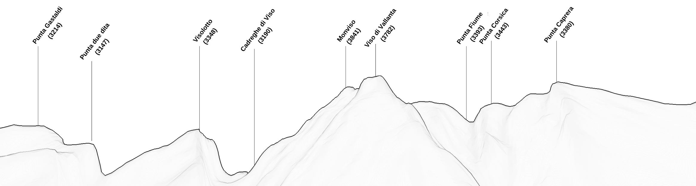
View from Rifugio Vallanta